About
Snow Distributed Radar Observation Platform (SnowDROP) is a European Space Agency (ESA) mission design concept which aims to observe snow density, stratigraphy and microstructure from remote sensing data. Such retrievals will improve snowpack representation in predictive models, and support a range of applications including avalanche forecasting, hydrology and climate research.
Justification
Despite the importance of snow density, microstructure and stratigraphy to the climate system, these variables remain absent from space-based Earth observation capabilities. Snow is an essential climate variable whose internal physical properties govern key Earth system dynamics such as surface energy balance, permafrost insulation, carbon release and avalanche hazard.
Approximately 70 % of the Earth’s fresh water is locked away in the form of snow or ice (WMO 2026), and mountain and Arctic snowpacks serve as vital
seasonal water storage mechanisms for nearly 2 billion people worldwide (UNESCO 2026). The WMO cites Snow Water Equivalent (SWE) as the highest priority unmet variable across terrestrial cryosphere monitoring and forecasting, and cryosphere climate monitoring as outlined by the scientific community, however, snow microstructure remains the primary technical barrier to improving SWE retrievals (WMO 2026).
There is currently capacity to retrieve detailed snowpack internal structure via ground based passive and active microwave sensors, for example, tomographic profiling of the structure of snow using Synthetic Aperture Radar (SAR) at a frequency of 9.2 – 17.8 GHz (X-band to Ku-band) has been demonstrated using SnowScat, a fully polarometric scatterometer (Frey, Werner, and Wiesmann 2015). Such SAR methods are able to non-destructively reveal the internal layering of the snowpack and are not constrained by day–night or cloud cover (Figure 1, Rekioua et al. 2017). Such methods have also been demonstrated using airborne methods but are yet to be applied to space-based capabilities.
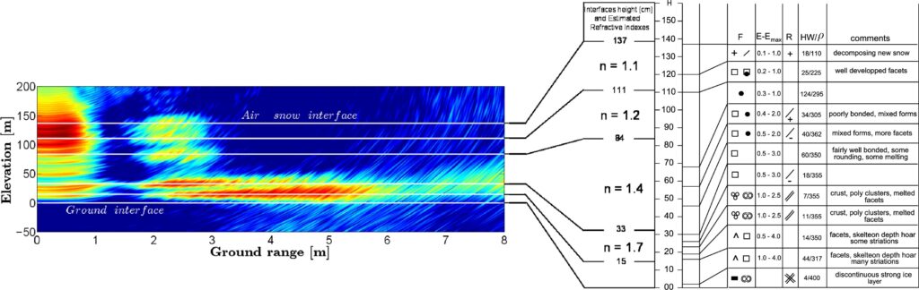
Rekioua et al. 2017; The panel on the right is the snow stratigraphy giving different
physical parameters of the snowpack as a function of depth. The estimated refractive indices are given for the different layers.
User requirements
A key objective of SnowDROP is to ensure that mission design is driven by the needs of the user community. In a previous survey for the Polarimetric Synthetic Aperture Radar Altimeter (PoSARA) satellite mission concept responses highlighted a need for ”instruments specifically designed for measurements of snow microstructure, depth and density at scales of 20km or less”. The SnowDROP user requirements survey aims to gather input from researchers and experts working with snow to better understand the observational requirements for snow properties stratigraphy, density and microstructure. The survey has 21 questions and takes approximately 10 – 15 minutes to complete.
SnowDROP user requirements survey – Fill in form
References
Frey, Othmar, Charles L. Werner, and Andreas Wiesmann (Sept. 2015). “Tomographic profiling of the structure of a snow pack at X-/Ku-Band using SnowScat in SAR mode”. In: 2015 European Radar Conference (EuRAD), pp.21–24. doi: 10.1109/EuRAD.2015.7346227. url: https://ieeexplore.ieee.org/abstract/document/7346227?casa_token=Fh9jZmcsm0IAAAAA:4YKJ8ZTquAYwpYhRcVJDrLo_jtX88tjfAvJNtU_v1h14YMiUNeAN2FrDDxQa7LSZxDhcpp6f (visited on 10/10/2023).
WMO (2026). Statement of Guidance for Earth System Application Category CryosphericApplications. Tech. rep., p. 91. url: https://library.wmo.int/idurl/4/6981
UNESCO(2026). Synthesis of the Decade of Action for Cryospheric Sciences 2025-203. Tech. rep. url: https://unesdoc.unesco.org/ark:/48223/pf0000397486.
Rekioua, Badreddine et al. (2017). “Snowpack permittivity profile retrieval from tomographic SAR data”. In: Comptes Rendus. Physique 18.1, pp. 57–65. DOI: 10.1016/j.crhy.2015.12.016